Pořejov, Tachov dist., Plzeň Region
Deserted town ‘Pořejov’
(14th–20th cent.)

Jewish cemetery in Pořejov.
Photo Z. Kačerová, 2013.
The town (former village) of Pořejov was founded in the first half of the 14th century and soon included the Church of St Bartholomew and a fortified manor, which was rebuilt in the 16th century into a small chateau. In the 18th century, the chateau and the near manorial farm were divided into parcels where, among other things, a synagogue and a Jewish school were built. The town suffered heavy damage in battles at the end of the Second World War and, following the expulsion of the German population, fell into decay. The ruins of the town were hauled away to a dump beginning in the 1980s.
References: Procházka 2005; Balý 2007; Galusová 2007; Vařeka a kol. 2008.
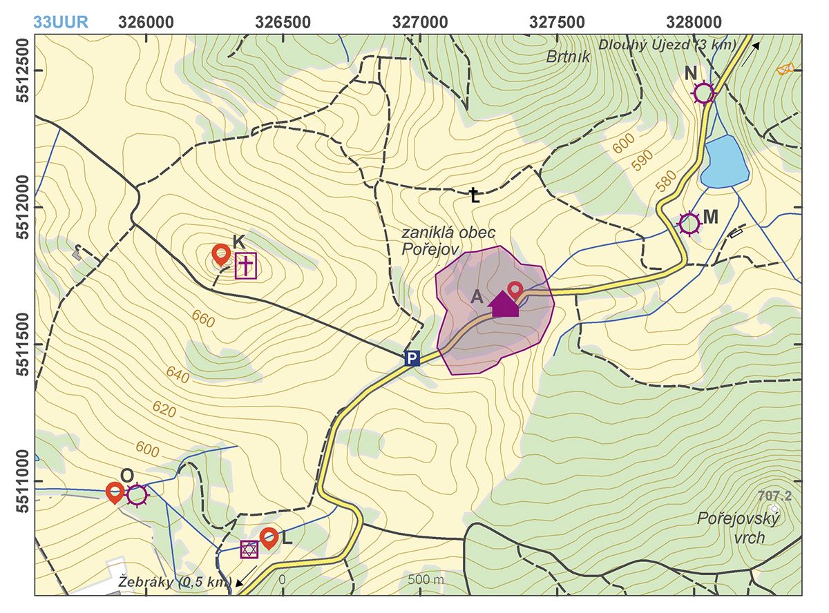
Navigation points: N 49°43'57.33", E 12°36'14.53"; N 49°44'00.17", E 12°35'20.93" (Church of St Anne); N 49°43'26.96", E 12°35'31.12" (Jewish cemetery); N 49°43'31.68", E 12°35'02.76".


Map notes: A – deserted town; B – Church of St Bartholomew; C – location of the fortified manor; D – pond, originally the moat of the manor; E – part of the manorial farm, site of the later Jewish school; F – three-compartment house; G – yard; H – barn; I – field boundaries; J – hollow ways; K – St Anne’s Church with cemetery; L – Jewish cemetery; M–O – deserted mills. Map symbols are available in the Downloads section.

Selected fulltext articles and reports for further reading. Complete bibliographical records are available in the Downloads section as the List of publications.
Archeologický atlas Čech – PořejovBalý, R. 2007: Odkaz staveb zaniklých po roce 1945 v Pořejově na Tachovsku na příkladu čp. 7. In: Dějiny staveb. Sborník příspěvků z konference Dějiny staveb 2007, 191–194.Balý, R. 2009: Zaniklá ves Pořejov na Tachovsku. Nepubl. diplomová práce, Katedra archeologie ZČU v Plzni.Galusová, L. 2007: Zaniklý Mášův mlýn. Příspěvek k poznání novověkých vodních mlýnů na Tachovsku. In: Dějiny staveb: sborník příspěvků z konference Dějiny staveb 2007, 201–204.Procházka, Z. 2005: Osudy čtyř zaniklých obcí. In: V. Dudák a kol., Český les: Příroda – historie – život, 201–204.Vařeka, P. a kol. 2008: Archeologický výzkum vesnic středověkého původu na Tachovsku zaniklých po roce 1945, Archaeologia historica 33, 101–117.